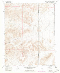
1968 Map of Scottys Junction SW
USGS Topo · Published 1982About this map
Slate Ridge dominates this high-desert landscape along the border of Esmeralda and Nye counties. This 1968 survey, revised in 1982, reveals a history of remote desert industry concentrated around isolated mining claims and critical water sources. The presence of the Silver Moon Mine, Gold Coin Mine, and Rattlesnake Mine suggests a period of hard-rock mineral prospecting in these arid uplands. Transportation through this challenging terrain was historically facilitated by an Old Railroad Grade cutting through the eastern flats, while modern access relies on various 4wd tracks. Vital water points such as Tokop Well and Anderson Well indicate the essential infrastructure required for survival and industrial operations in this Nevada backcountry.
Find a feature on this map
14 named features on this map. Tap any name to fly to it.
Don’t see what you’re looking for? This feature index may not catch every label — zoom into the map to look around manually.
Map Details
Editions of this 1968 Scottys Junction SW Map
2 editions found
Other maps of this area

1908 · Lida
USGS Topo · 1:250,000

1913 · Lida
USGS Topo · 1:250,000

1954 · Goldfield
USGS Topo · 1:250,000

1955 · Goldfield
USGS Topo · 1:250,000

1957 · Ubehebe Crater
USGS Topo · 1:62,500

1958 · Goldfield
USGS Topo · 1:250,000

1962 · Goldfield
USGS Topo · 1:250,000

1968 · Stonewall Pass
USGS Topo · 1:24,000
1968 · Bonnie Claire NW
USGS Topo · 1:24,000
1968 · Gold Point
USGS Topo · 1:24,000