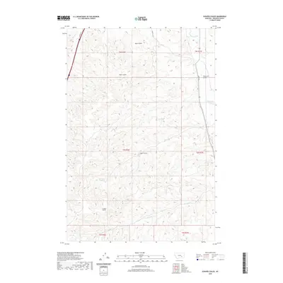
2020 Map of Scraper Coulee
USGS Topo · Published 2020About this map
Scraper Coulee and its neighboring drainages define this stretch of Treasure County, Montana, as it appeared in the early 21st century. The landscape is characterized by a dense network of coulees and creeks that feed the Yellowstone River watershed, including the prominent Box Elder Cr and the winding Sarpy Cr. While the terrain is primarily natural, human infrastructure is visible in the form of the Hysham Canal in the northeast corner and local thoroughfares like Cemetery Rd and Gumbo Hill Rd. Isolated water sources such as Sandrock Spring and Garverich Spring provide critical landmarks in an area dominated by intricate topographic relief. The map reveals the interplay between the dry, dissected uplands of Cedar Coulee and the vital water-management systems essential for local agriculture.
Find a feature on this map
21 named features on this map. Tap any name to fly to it.
Don’t see what you’re looking for? This feature index may not catch every label — zoom into the map to look around manually.
Map Details
Editions of this 2020 Scraper Coulee Map
This is the sole edition of this map. No revisions or reprints were ever made.
Other maps of this area

1954 · Forsyth
USGS Topo · 1:250,000

1957 · Forsyth
USGS Topo · 1:250,000

1958 · Forsyth
USGS Topo · 1:250,000

1960 · Hysham
USGS Topo · 1:24,000

1960 · Myers
USGS Topo · 1:24,000

1960 · Sanders
USGS Topo · 1:24,000

1960 · Eldering Ranch
USGS Topo · 1:24,000

1960 · Hope Ranch
USGS Topo · 1:24,000
1972 · Minnehaha Creek North
USGS Topo · 1:24,000
1972 · South Bear Creek
USGS Topo · 1:24,000