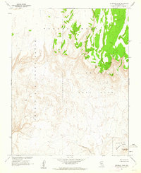
1961 Map of Scrugham Peak
USGS Topo · Published 1962About this map
Nevada Test Site lands dominate this 1961 survey, produced in cooperation with the Atomic Energy Commission during a period of intense Cold War activity. The map reveals the stark topography of the Air Force Range, where the high plateau of Pahute Mesa gives way to complex drainage systems like Fortymile Canyon. This specific quadrant includes Area 18, a designation reflecting the administrative partitioning of the desert for specialized military and scientific use.
Find a feature on this map
10 named features on this map. Tap any name to fly to it.
Don’t see what you’re looking for? This feature index may not catch every label — zoom into the map to look around manually.
Map Details
Editions of this 1961 Scrugham Peak Map
This is the sole edition of this map. No revisions or reprints were ever made.
Other maps of this area

1908 · Kawich
USGS Topo · 1:250,000

1942 · Tolicha Peak
USGS Topo · 1:125,000

1942 · Wheelbarrow Peak
USGS Topo · 1:125,000

1952 · Timber Mountain
USGS Topo · 1:62,500

1952 · Silent Canyon
USGS Topo · 1:62,500
1952 · Black Mtn
USGS Topo · 1:62,500

1954 · Goldfield
USGS Topo · 1:250,000

1955 · Goldfield
USGS Topo · 1:250,000

1958 · Goldfield
USGS Topo · 1:250,000
1961 · Ammonia Tanks
USGS Topo · 1:24,000