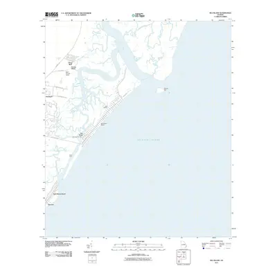
2011 Map of Sea Island
USGS Topo · Published 2011About this map
Saint Simons Island and its smaller neighbor Sea Island define this coastal landscape, separated by the winding course of Village Creek. At this point in the early twenty-first century, the shoreline exhibits a mix of established residential areas and tidal marshlands. Notable clusters of settlement include Village Bluff, German Village, and Harrington on the northern end of Saint Simons, while Sea Island is characterized by its linear development along Sea Island Dr and Ocean Rd. The presence of the Sea Island Post Office and the distinct neighborhoods of Black Banks and East End illustrate the continued growth of these barrier island communities. The intricate network of tidal waterways, including the Hampton River, Mosquito Creek, and Postell Creek, provides a detailed look at the geography of the Georgia coast before shifting sands like Pelican Spit inevitably alter the maritime boundaries.
Find a feature on this map
23 named features on this map. Tap any name to fly to it.
Don’t see what you’re looking for? This feature index may not catch every label — zoom into the map to look around manually.
Map Details
Editions of this 2011 Sea Island Map
This is the sole edition of this map. No revisions or reprints were ever made.
Other maps of this area

1920 · Cabretta Island
USGS Topo · 1:62,500

1921 · Darien
USGS Topo · 1:62,500

1944 · Cabretta Island
USGS Topo · 1:62,500

1945 · Brunswick
USGS Topo · 1:62,500

1946 · Brunswick
USGS Topo · 1:250,000

1948 · Brunswick
USGS Topo · 1:250,000

1954 · Altamaha Sound
USGS Topo · 1:24,000
1955 · Sea Island
USGS Topo · 1:24,000
1956 · Brunswick East
USGS Topo · 1:24,000
1956 · Darien
USGS Topo · 1:24,000