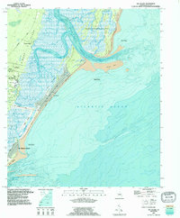
1993 Map of Sea Island
USGS Topo · Published 1995About this map
Simons Island and Little Saint Simons Island are separated by the complex tidal reaches of the Hampton River in this detailed topographic and bathymetric study. The map illustrates the developed residential and recreational character of the coastline, featuring the Golf Course at Sea Palms and the exclusive stretch of Sea Island Beach. Local history is preserved in markers such as German Village and Harrington, along with St Andrews Ch and an adjacent Cem. The hydrographic data provides depth contours for the Atlantic Ocean and major channels like Village Creek and the Blackbank River. Coastal change is a constant theme, with notes indicating that areas near Pelican Spit and Goulds Inlet are subject to frequent change. The presence of the US Coast Guard Station on the southern end of the map emphasizes the maritime importance of the sound.
Find a feature on this map
28 named features on this map. Tap any name to fly to it.
Don’t see what you’re looking for? This feature index may not catch every label — zoom into the map to look around manually.
Map Details
Editions of this 1993 Sea Island Map
This is the sole edition of this map. No revisions or reprints were ever made.
Other maps of this area

1920 · Cabretta Island
USGS Topo · 1:62,500

1921 · Darien
USGS Topo · 1:62,500

1944 · Cabretta Island
USGS Topo · 1:62,500

1945 · Brunswick
USGS Topo · 1:62,500

1946 · Brunswick
USGS Topo · 1:250,000

1948 · Brunswick
USGS Topo · 1:250,000

1954 · Altamaha Sound
USGS Topo · 1:24,000
1955 · Sea Island
USGS Topo · 1:24,000
1956 · Brunswick East
USGS Topo · 1:24,000
1956 · Darien
USGS Topo · 1:24,000