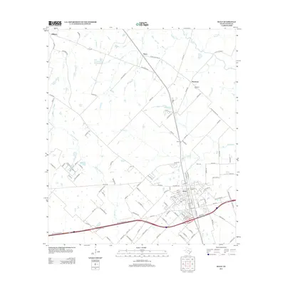
2013 Map of Sealy
USGS Topo · Published 2013About this map
Sealy serves as a central hub of Austin County activity in the early 21st century, where the local street grid converges near significant community landmarks such as Sealy Cem. The surrounding landscape is defined by the winding paths of Little Bernard Cr and Allens Cr, which segment the agricultural and residential outskirts. North of the main settlement, the smaller communities of Peters and Macedonia maintain their own identities, with the Macedonia Cem and Glenn Cem providing vital points of interest for genealogical research. The map demonstrates a transition from the structured residential blocks of the town center to the vast rural stretches defined by historical watercourses like Bullinger Cr and Deadman Cr. Transport is anchored by the modern infrastructure of NW I 10 Frontage Rd, which runs parallel to the primary east-west thoroughfare.
Find a feature on this map
120 named features on this map. Tap any name to fly to it.
Don’t see what you’re looking for? This feature index may not catch every label — zoom into the map to look around manually.
Map Details
Editions of this 2013 Sealy Map
This is the sole edition of this map. No revisions or reprints were ever made.
Other maps of this area

1953 · Seguin
USGS Topo · 1:250,000

1956 · Bellville
USGS Topo · 1:62,500

1956 · Sealy
USGS Topo · 1:62,500

1956 · Wallis
USGS Topo · 1:62,500

1957 · Eagle Lake
USGS Topo · 1:62,500

1958 · Seguin
USGS Topo · 1:250,000

1960 · Wallis
USGS Topo · 1:24,000

1960 · San Felipe
USGS Topo · 1:24,000
1960 · Rexville
USGS Topo · 1:24,000
1960 · Sealy
USGS Topo · 1:24,000