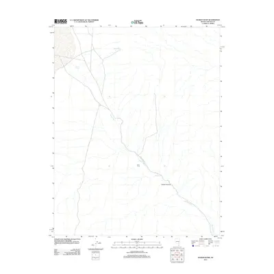
2012 Map of Seaman Wash
USGS Topo · Published 2012About this map
Seaman Wash defines this portion of Lincoln County, serving as the primary drainage and orientation point for a landscape shaped by intermittent water. The map shows the winding course of the wash as it passes through the Seaman Narrows, a distinct topographical pinch point. To the northwest, Seaman Spring and Tule Reservoir indicate localized water management, while the presence of the Norton Fence suggests long-established ranching boundaries or land use partitions in an otherwise open corridor. The transit across this region is primarily facilitated by Seaman Wash Rd, which follows the natural grade of the valley floor towards the water source at Ash Springs. This 2012 survey illustrates the fundamental relationship between desert hydrology and the sparse infrastructure required to manage it.
Find a feature on this map
7 named features on this map. Tap any name to fly to it.
Don’t see what you’re looking for? This feature index may not catch every label — zoom into the map to look around manually.
Map Details
Editions of this 2012 Seaman Wash Map
This is the sole edition of this map. No revisions or reprints were ever made.
Other maps of this area

1954 · Caliente
USGS Topo · 1:250,000

1959 · Caliente
USGS Topo · 1:250,000

1970 · Hiko NE
USGS Topo · 1:24,000

1970 · Oreana Spring
USGS Topo · 1:24,000

1970 · Seaman Wash
USGS Topo · 1:24,000

1970 · Fossil Peak
USGS Topo · 1:24,000
1970 · Weepah Spring
USGS Topo · 1:24,000
1970 · White River Narrows
USGS Topo · 1:24,000

1985 · Mail Summit
USGS Topo · 1:24,000

1985 · Coal Valley Reservoir
USGS Topo · 1:24,000