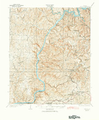
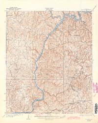
1934 Map of Searles
USGS Topo · Published 1942About this map
The Black Warrior River dominates this landscape, serving as a vital industrial artery as it snakes between the Tuscaloosa and Jefferson county lines. In the late 1920s, a series of engineering works including Lock No 16, Lock No 15, and Lock No 14 managed the river's descent, supporting the heavy transport needs of the coal and timber country. The southeastern corner shows a dense concentration of company towns and rail infrastructure, where the Mobile and Ohio Railroad and the Louisville and Nashville Railroad converge near Brookwood and Searles. Away from the river and rail lines, the topography rises into family-named ridges like Graveyard Ridge and peaks such as Iron Ore Mountain. This survey captures a moment of transition where established rural communities centered on Pattons Mill and Spencer Hill Sch existed alongside the rising industrial scale of the regional mining and transit networks.
Find a feature on this map
101 named features on this map. Tap any name to fly to it.
Don’t see what you’re looking for? This feature index may not catch every label — zoom into the map to look around manually.
Map Details
Editions of this 1934 Searles Map
6 editions found

Other maps of this area

1893 · Jasper
USGS Topo · 1:125,000

1899 · Brookwood
USGS Topo · 1:125,000

1924 · Tuscaloosa
USGS Topo · 1:62,500

1926 · Samantha
USGS Topo · 1:48,000

1926 · Tuscaloosa
USGS Topo · 1:62,500

1927 · Adger
USGS Topo · 1:48,000

1928 · Samantha
USGS Topo · 1:62,500

1929 · Searles
USGS Topo · 1:48,000

1931 · Cottondale
USGS Topo · 1:48,000

1932 · Yolande
USGS Topo · 1:62,500