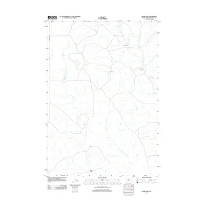
2012 Map of Sears Dam
USGS Topo · Published 2012About this map
Mitchell Ranch and Holmes Ranch anchor the wide, unpopulated landscape of Ziebach County in this early 21st-century record. The terrain is defined by the winding paths of Cottonwood Cr and its tributaries, including Little Cottonwood Cr and the E Fork Little Cottonwood Cr. This area is characterized by scattered ranching operations and water management infrastructure essential for livestock and local agriculture in a semi-arid environment. Key points of interest include Sears Dam and Campbell Dam, which provide vital water catchment in the northern Great Plains. Navigation through this remote cattle country is largely dependent on unpaved routes, with Cherry Creek Rd serving as a primary artery on the western edge of the quadrangle.
Find a feature on this map
10 named features on this map. Tap any name to fly to it.
Don’t see what you’re looking for? This feature index may not catch every label — zoom into the map to look around manually.
Map Details
Editions of this 2012 Sears Dam Map
This is the sole edition of this map. No revisions or reprints were ever made.
Other maps of this area

1954 · Pierre
USGS Topo · 1:250,000

1955 · Rattlesnake Lake
USGS Topo · 1:24,000

1955 · Rattlesnake Lake NE
USGS Topo · 1:24,000

1956 · Cherry Creek NW
USGS Topo · 1:24,000

1958 · Pierre
USGS Topo · 1:250,000

1981 · High Elk Hill NW
USGS Topo · 1:24,000

1981 · High Elk Hill SW
USGS Topo · 1:24,000

1982 · Miller Dam
USGS Topo · 1:24,000

1982 · Longbrake Ranch
USGS Topo · 1:24,000
1982 · Diermier Ranch
USGS Topo · 1:24,000