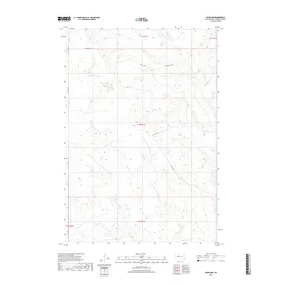
2017 Map of Sears Dam
USGS Topo · Published 2017About this map
Little Cottonwood Cr and its eastern fork wind through this Ziebach County landscape, highlighting a region defined by its water management and grazing infrastructure. The prominence of Sears Dam and Campbell Dam underscores the vital role of stock ponds and reservoirs in this South Dakota terrain. This modern survey reflects the established grid of the Public Land Survey System, featuring township boundaries such as t10n r21e and t11n r21e. While the land remains largely open, a network of local roads including Cherry Creek Rd and Sunnybrook Rd provides access to the interior. Small-scale naming conventions like Wall St and Mitchell Blvd suggest local points of interest or ranch access roads within the expansive prairie geography of the Cheyenne River watershed area.
Find a feature on this map
15 named features on this map. Tap any name to fly to it.
Don’t see what you’re looking for? This feature index may not catch every label — zoom into the map to look around manually.
Map Details
Editions of this 2017 Sears Dam Map
This is the sole edition of this map. No revisions or reprints were ever made.
Other maps of this area

1954 · Pierre
USGS Topo · 1:250,000

1955 · Rattlesnake Lake
USGS Topo · 1:24,000

1955 · Rattlesnake Lake NE
USGS Topo · 1:24,000

1956 · Cherry Creek NW
USGS Topo · 1:24,000

1958 · Pierre
USGS Topo · 1:250,000

1981 · High Elk Hill NW
USGS Topo · 1:24,000

1981 · High Elk Hill SW
USGS Topo · 1:24,000

1982 · Miller Dam
USGS Topo · 1:24,000

1982 · Longbrake Ranch
USGS Topo · 1:24,000
1982 · Diermier Ranch
USGS Topo · 1:24,000