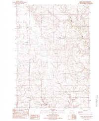
1982 Map of Sears Dam
USGS Topo · Published 1983About this map
Sunnybrook Ch stands as a focal point for the rural community in this portion of Ziebach County, situated on the high plains within the Cheyenne River Indian Reservation. This 1982 provisional survey illustrates a landscape defined by the drainage systems of Cottonwood Creek and Little Cottonwood Creek, where the hydrology is managed through features like Sears Dam and Campbell Dam. The map reveals a pattern of isolated pastoral settlement, with numerous family-named operations including the Mitchell Ranch, Holmes Ranch, Wall Ranch, and Knight Ranch scattered across the undulating terrain. A distinctive natural feature, the seasonally appearing Dry Lake, highlights the arid character of the region. These details reflect the enduring ranching economy of South Dakota's interior, providing a clear record of land use and family holdings during the late twentieth century.
Find a feature on this map
11 named features on this map. Tap any name to fly to it.
Don’t see what you’re looking for? This feature index may not catch every label — zoom into the map to look around manually.
Map Details
Editions of this 1982 Sears Dam Map
This is the sole edition of this map. No revisions or reprints were ever made.
Other maps of this area

1954 · Pierre
USGS Topo · 1:250,000

1955 · Rattlesnake Lake
USGS Topo · 1:24,000

1955 · Rattlesnake Lake NE
USGS Topo · 1:24,000

1956 · Cherry Creek NW
USGS Topo · 1:24,000

1958 · Pierre
USGS Topo · 1:250,000

1981 · High Elk Hill NW
USGS Topo · 1:24,000

1981 · High Elk Hill SW
USGS Topo · 1:24,000

1982 · Miller Dam
USGS Topo · 1:24,000

1982 · Longbrake Ranch
USGS Topo · 1:24,000
1982 · Diermier Ranch
USGS Topo · 1:24,000