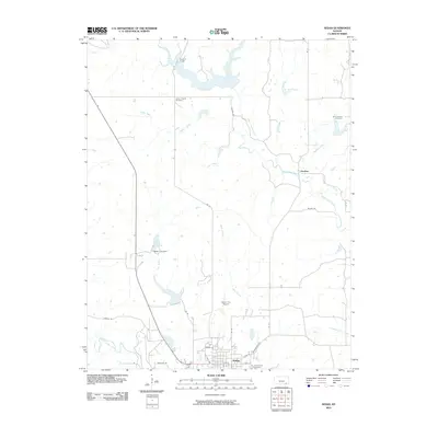
2010 Map of Sedan
USGS Topo · Published 2010About this map
Sedan serves as the focal point of this Chautauqua County survey, situated at the intersection of several regional routes like Independence Rd and Kansas Rd. The landscape is defined by the drainage systems of Middle Caney Creek and North Caney Creek, which create a network of winding waterways across the prairie. Local infrastructure is well-documented, featuring the Sedan City Airport and the Sedan City Dam which impounds Sedan City Lake to the northwest of the town center. Genealogists will find significant value in the clear locations of several burial grounds, including Union Chapel Cemetery, Saint Charles Cemetery, and Greenwood Cemetery. To the north, the terrain transitions toward Quivira Camp and Tanglewood Lake, illustrating the mix of municipal utility and rural recreation that characterizes the region during this era.
Find a feature on this map
32 named features on this map. Tap any name to fly to it.
Don’t see what you’re looking for? This feature index may not catch every label — zoom into the map to look around manually.
Map Details
Editions of this 2010 Sedan Map
This is the sole edition of this map. No revisions or reprints were ever made.
Other maps of this area

1885 · Sedan
USGS Topo · 1:125,000

1889 · Sedan
USGS Topo · 1:125,000

1955 · Wichita
USGS Topo · 1:250,000

1958 · Wichita
USGS Topo · 1:250,000
1962 · Oak Valley
USGS Topo · 1:24,000

1962 · Moline
USGS Topo · 1:24,000
1962 · Elk Falls
USGS Topo · 1:24,000

1962 · Sedan
USGS Topo · 1:24,000

1962 · Elgin NE
USGS Topo · 1:24,000
1962 · Elgin
USGS Topo · 1:24,000