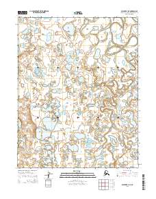
2015 Map of Selawik B-1 NE
USGS Topo · Published 2015About this map
The Selawik River meanders through a labyrinth of freshwater lakes and wetlands in this remote Arctic landscape. This hydrologic network is dominated by the sprawling oxbows of the Tagagawik River, which winds through the southern and eastern portions of the quadrangle. The map documents a complex system of thermokarst lakes and interconnected waterways that define the northern tundra. Surveyed by the U.S. Geological Survey, the terrain is marked by township and range boundaries including t12n r2w and t13n r3w, though the area remains void of permanent structures or roads. This document preserves the precise state of the river channels and shoreline configurations as they existed before further shifts in the permafrost landscape.
Find a feature on this map
8 named features on this map. Tap any name to fly to it.
Don’t see what you’re looking for? This feature index may not catch every label — zoom into the map to look around manually.
Map Details
Editions of this 2015 Selawik B-1 NE Map
This is the sole edition of this map. No revisions or reprints were ever made.
Other maps of this area

1951 · Selawik
USGS Topo · 1:250,000

1951 · Shungnak
USGS Topo · 1:250,000

1955 · Shungnak
USGS Topo · 1:250,000

1957 · Selawik
USGS Topo · 1:250,000

1964 · Shungnak
USGS Topo · 1:250,000
1985 · Shungnak B-6
USGS Topo · 1:63,360
1985 · Selawik C-1
USGS Topo · 1:63,360
1985 · Selawik B-1
USGS Topo · 1:63,360
1985 · Shungnak C-6
USGS Topo · 1:63,360
2015 · Selawik B-1 SW
USGS Topo · 1:25,000