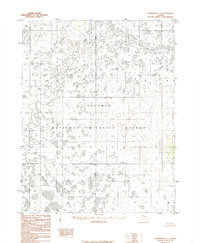
1985 Map of Shungnak C-6
USGS Topo · Published 1985About this map
The Selawik National Wildlife Refuge dominates this subarctic landscape, characterized by a complex network of wetlands and meandering waterways. Surveyed via aerial photography in the early 1970s and edited in the mid-1980s, the map reveals a remote terrain defined by the slow movements of the Kateel River and its various tributaries. The hydrology here is dense and intricate, with the Kugarak River and Kuchuk Creek cutting through a mosaic of lakes and marshy ground typical of the region's permafrost-influenced geography. Further south, the Kawichiark River flows through the refuge, which was established by the Alaska National Interest Lands Conservation Act shortly before this map's publication. This survey serves as a record of the area's natural state before more recent climatic shifts impacted the Arctic tundra and its drainage patterns.
Find a feature on this map
5 named features on this map. Tap any name to fly to it.
Don’t see what you’re looking for? This feature index may not catch every label — zoom into the map to look around manually.
Map Details
Editions of this 1985 Shungnak C-6 Map
This is the sole edition of this map. No revisions or reprints were ever made.
Other maps of this area

1951 · Selawik
USGS Topo · 1:250,000

1951 · Shungnak
USGS Topo · 1:250,000

1955 · Shungnak
USGS Topo · 1:250,000

1955 · Shungnak D-6
USGS Topo · 1:63,360

1955 · Shungnak D-5
USGS Topo · 1:63,360
1955 · Selawik D-1
USGS Topo · 1:63,360

1957 · Selawik
USGS Topo · 1:250,000

1964 · Shungnak
USGS Topo · 1:250,000
1985 · Shungnak B-6
USGS Topo · 1:63,360
1985 · Selawik C-1
USGS Topo · 1:63,360