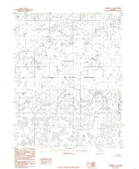
1985 Map of Selawik C-1
USGS Topo · Published 1985About this map
The Selawik River meanders in tight, complex oxbows through this portion of the Selawik National Wildlife Refuge as documented in the mid-1980s. This interior Alaskan landscape is defined by its watery geography, where the main river course meets the Kugarak River amidst a dense network of unnamed lakes and wetlands. The small settlement of Nilik represents a singular point of human habitation along the riverbank in an otherwise unsettled expanse. Compiled from aerial photography taken in 1971 and edited in 1985, this record illustrates the shifting hydrology of the Arctic tundra before the more rapid environmental changes of the late 20th century. The lack of roads or established trails on the sheet emphasizes the reliance on these river systems for navigation and access to the interior.
Find a feature on this map
9 named features on this map. Tap any name to fly to it.
Don’t see what you’re looking for? This feature index may not catch every label — zoom into the map to look around manually.
Map Details
Editions of this 1985 Selawik C-1 Map
This is the sole edition of this map. No revisions or reprints were ever made.
Other maps of this area

1951 · Selawik
USGS Topo · 1:250,000

1951 · Shungnak
USGS Topo · 1:250,000

1955 · Shungnak
USGS Topo · 1:250,000

1955 · Selawik D-2
USGS Topo · 1:63,360

1955 · Shungnak D-6
USGS Topo · 1:63,360
1955 · Selawik D-1
USGS Topo · 1:63,360

1957 · Selawik
USGS Topo · 1:250,000

1964 · Shungnak
USGS Topo · 1:250,000
1985 · Shungnak B-6
USGS Topo · 1:63,360
1985 · Selawik B-2
USGS Topo · 1:63,360