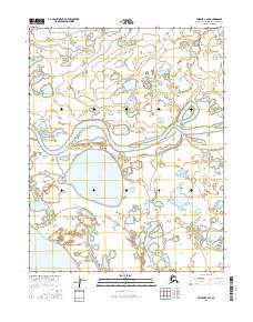
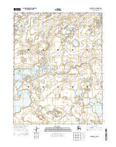
2016 Map of Selawik C-2 SE
USGS Topo · Published 2016About this map
Selawik River meanders across this sub-arctic landscape, defining the hydrological character of a region dominated by water and wetlands. The river course, characterized by wide oxbows and slow-moving channels, separates several significant water bodies including Kanisokrok Lake and the smaller Knoxville Lake to the north. Near the southwestern edge of the survey, the margins of Inland Lake begin to appear, illustrating the complex lacustrine environment of the Northwest Arctic Borough. This 2016 survey provides a record of the intricate drainages and pond systems that shape the traditional hunting and fishing grounds of the region, documenting the land within the t14n r5w and t13n r5w townships before environmental shifts further alter the low-lying tundra terrain.
Find a feature on this map
8 named features on this map. Tap any name to fly to it.
Don’t see what you’re looking for? This feature index may not catch every label — zoom into the map to look around manually.
Map Details
Editions of this 2016 Selawik C-2 SE Map
This is the sole edition of this map. No revisions or reprints were ever made.
Other maps of this area

1951 · Selawik
USGS Topo · 1:250,000

1957 · Selawik
USGS Topo · 1:250,000
1985 · Selawik C-1
USGS Topo · 1:63,360
1985 · Selawik B-2
USGS Topo · 1:63,360
1985 · Selawik C-2
USGS Topo · 1:63,360
1985 · Selawik B-1
USGS Topo · 1:63,360
2015 · Selawik C-1 NW
USGS Topo · 1:25,000
2015 · Selawik C-1 SW
USGS Topo · 1:25,000
2015 · Selawik C-2 NW
USGS Topo · 1:25,000
2015 · Selawik C-2 NE
USGS Topo · 1:25,000