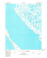
1951 Map of Selawik C-6
USGS Topo · Published 1983About this map
The Selawik National Wildlife Refuge dominates the eastern half of this 1951 survey, characterized by a complex network of aquatic pathways within the delta. Waterways such as the Riley Channel, Rich Channel, and Olikatuk Channel weave through the refuge's wetlands, illustrating a landscape defined by seasonal hydrological changes. To the west, the Baldwin Peninsula forms a prominent landmass separating the waters of Hotham Inlet from the broader Kotzebue Sound. The map’s reliance on 1951 aerial photography highlights a period of remote Arctic mapping where physical access was limited, focusing on the fundamental shoreline and drainage patterns. This document preserves the exact coastal and deltaic configuration before later environmental shifts, offering researchers a baseline for the region's geography at the midpoint of the twentieth century.
Find a feature on this map
10 named features on this map. Tap any name to fly to it.
Don’t see what you’re looking for? This feature index may not catch every label — zoom into the map to look around manually.
Map Details
Editions of this 1951 Selawik C-6 Map
3 editions found
Other maps of this area

1951 · Selawik
USGS Topo · 1:250,000

1951 · Kotzebue
USGS Topo · 1:250,000

1951 · Kotzebue D-1
USGS Topo · 1:63,360

1951 · Selawik C-6
USGS Topo · 1:63,360

1951 · Selawik B-6
USGS Topo · 1:63,360

1951 · Selawik D-6
USGS Topo · 1:63,360

1951 · Selawik B-5
USGS Topo · 1:63,360
1951 · Kotzebue C-1
USGS Topo · 1:63,360

1952 · Selawik D-6
USGS Topo · 1:63,360

1955 · Selawik D-5
USGS Topo · 1:63,360