
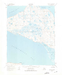
1951 Map of Selawik B-5
USGS Topo · Published 1957About this map
The Baldwin Peninsula dominates this coastal survey, serving as a massive land bridge between the waters of Hotham Inlet and Eschscholtz Bay. Mapped by the Army Map Service using 1951 aerial photography, the landscape is defined by an intricate network of tundra ponds and thermokarst lakes, illustrating the complex hydrology of the Northwest Arctic region. At the southern tip, Elephant Point and the nearby Baldwin Seaplane Base provide critical maritime and aerial navigation points along the bay's edge.
Find a feature on this map
12 named features on this map. Tap any name to fly to it.
Don’t see what you’re looking for? This feature index may not catch every label — zoom into the map to look around manually.
Map Details
Editions of this 1951 Selawik B-5 Map
2 editions found
Other maps of this area

1951 · Selawik
USGS Topo · 1:250,000

1951 · Selawik C-6
USGS Topo · 1:63,360

1951 · Selawik B-6
USGS Topo · 1:63,360

1951 · Selawik A-5
USGS Topo · 1:63,360

1951 · Selawik A-6
USGS Topo · 1:63,360

1955 · Selawik A-4
USGS Topo · 1:63,360

1955 · Selawik B-4
USGS Topo · 1:63,360

1955 · Selawik C-5
USGS Topo · 1:63,360

1955 · Selawik C-4
USGS Topo · 1:63,360

1957 · Selawik
USGS Topo · 1:250,000