
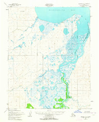
1951 Map of Selawik A-5
USGS Topo · Published 1957About this map
Buckland River meanders through the low-lying coastal tundra of the Alaska-Second Judicial Division, carving a complex path toward the waters of Eschscholtz Bay. This 1951 photogrammetric survey reveals a landscape defined by water and ice, where the braided river delta meets the bay at Igloo Pt. The topography indicates the vital seasonal uses of the land, most notably at the Reindeer Corral and a cluster of nearby Cabins, reflecting the subsistence and herding traditions of the region. These few named markers of human presence are concentrated near the coastline, while the interior remains a web of wetlands drained by Duck Creek and Dick Slough. To the northwest, the prominent rising ground of Elephant Point stands as a landmark overlooking the southern reaches of the bay, providing a stable geographic anchor in a shifting environment of marshes and tidal flats.
Find a feature on this map
8 named features on this map. Tap any name to fly to it.
Don’t see what you’re looking for? This feature index may not catch every label — zoom into the map to look around manually.
Map Details
Editions of this 1951 Selawik A-5 Map
2 editions found
Other maps of this area

1951 · Candle
USGS Topo · 1:250,000

1951 · Selawik
USGS Topo · 1:250,000

1951 · Candle D-5
USGS Topo · 1:63,360

1951 · Selawik B-6
USGS Topo · 1:63,360

1951 · Candle D-6
USGS Topo · 1:63,360

1951 · Selawik B-5
USGS Topo · 1:63,360

1951 · Selawik A-6
USGS Topo · 1:63,360

1955 · Candle
USGS Topo · 1:250,000

1955 · Selawik A-4
USGS Topo · 1:63,360

1955 · Candle D-4
USGS Topo · 1:63,360