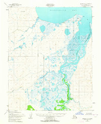
1951 Map of Selawik A-5
USGS Topo · Published 1964About this map
Eschscholtz Bay and the winding course of the Buckland River dominate this landscape on the northern coast of Alaska. Surveyed in the early 1950s, the map reveals a remote environment where subsistence and seasonal activity are marked by isolated Cabins and a Reindeer Corral near the shoreline. The topography is defined by low-lying wetlands and complex drainage systems, including Duck Creek and Dick Slough, which cut through the tundra toward the bay. Notable coastal landmarks such as Elephant Point and Igloo Pt provide essential navigation references along the water's edge. The land lines shown represent unsurveyed and unmarked locations predetermined by the Bureau of Land Management, reflecting the vast, untamed nature of the Northwest Arctic during this era.
Find a feature on this map
15 named features on this map. Tap any name to fly to it.
Don’t see what you’re looking for? This feature index may not catch every label — zoom into the map to look around manually.
Map Details
Editions of this 1951 Selawik A-5 Map
2 editions found
Other maps of this area

1951 · Candle
USGS Topo · 1:250,000

1951 · Selawik
USGS Topo · 1:250,000

1951 · Candle D-5
USGS Topo · 1:63,360

1951 · Selawik B-6
USGS Topo · 1:63,360

1951 · Selawik A-5
USGS Topo · 1:63,360

1951 · Candle D-6
USGS Topo · 1:63,360

1951 · Selawik B-5
USGS Topo · 1:63,360

1951 · Selawik A-6
USGS Topo · 1:63,360

1955 · Candle
USGS Topo · 1:250,000

1955 · Selawik A-4
USGS Topo · 1:63,360