
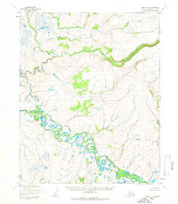
1955 Map of Selawik A-4
USGS Topo · Published 1966About this map
The Selawik Hills dominate the interior of this Arctic landscape, where topographical data was compiled from 1955 aerial photography. This interior region of the Northwest Arctic is defined by seasonal movement and remote landmarks, evidenced by the presence of a Winter Trail navigating the western lowlands near the Buckland River. The map marks localized high points and named landmarks such as Emmaus, Buckland, and Saturday, which likely served as crucial orientation points for travelers in an era when land lines remained largely unsurveyed. To the north, the Kauk River and Harvey Creek drain the upland slopes, illustrating the complex hydrology of the tundra before extensive modern development altered the region's accessibility.
Find a feature on this map
8 named features on this map. Tap any name to fly to it.
Don’t see what you’re looking for? This feature index may not catch every label — zoom into the map to look around manually.
Map Details
Editions of this 1955 Selawik A-4 Map
This is the sole edition of this map. No revisions or reprints were ever made.
Other maps of this area

1951 · Candle
USGS Topo · 1:250,000

1951 · Selawik
USGS Topo · 1:250,000

1951 · Candle D-5
USGS Topo · 1:63,360

1951 · Selawik A-5
USGS Topo · 1:63,360

1951 · Selawik B-5
USGS Topo · 1:63,360

1955 · Candle
USGS Topo · 1:250,000

1955 · Candle D-4
USGS Topo · 1:63,360

1955 · Selawik B-3
USGS Topo · 1:63,360
1955 · Candle D-3
USGS Topo · 1:63,360

1955 · Selawik A-3
USGS Topo · 1:63,360