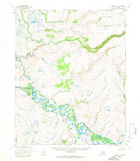
1955 Map of Candle D-3
USGS Topo · Published 1966About this map
The Buckland River meanders through this portion of the Candle D-3 quadrangle, forming a complex network of oxbow lakes and wetlands. Surveyed in the mid-1950s, the landscape is defined by the watercourses that dominate the terrain, including the Fish River in the northern reaches and Brush Creek feeding into the main channel from the south. This area, mapped by the Army Map Service using photogrammetric methods, shows an environment largely untouched by permanent settlement or road infrastructure at the time of the survey.
Find a feature on this map
4 named features on this map. Tap any name to fly to it.
Don’t see what you’re looking for? This feature index may not catch every label — zoom into the map to look around manually.
Map Details
Editions of this 1955 Candle D-3 Map
This is the sole edition of this map. No revisions or reprints were ever made.
Other maps of this area

1951 · Candle
USGS Topo · 1:250,000

1951 · Selawik
USGS Topo · 1:250,000

1954 · Candle C-2
USGS Topo · 1:63,360

1954 · Candle D-2
USGS Topo · 1:63,360

1955 · Candle
USGS Topo · 1:250,000

1955 · Selawik A-4
USGS Topo · 1:63,360

1955 · Candle D-4
USGS Topo · 1:63,360

1955 · Candle C-4
USGS Topo · 1:63,360

1955 · Candle C-3
USGS Topo · 1:63,360

1955 · Selawik A-3
USGS Topo · 1:63,360