
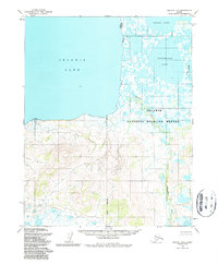
1955 Map of Selawik B-3
USGS Topo · Published 1966About this map
Selawik Lake dominates the western horizon of this mid-century survey, where the brackish waters meet a complex network of wetlands and tundra. The geography is defined by the hydrologic connection between Inland Lake and the larger Tuklomarak Lake, woven together by the meandering course of the Mangoak River. This landscape reflects the untouched coastal plains of the Northwest Arctic, where the transition from open water to marshland is fluid and ever-shifting. To the east, the Fox River cuts through the low-lying terrain, marking a distinct drainage pattern typical of the region's arctic coastal plain. The absence of roads or permanent settlements in this 1955 record underscores the isolation of the area, emphasizing a terrain shaped entirely by water and seasonal freeze-thaw cycles rather than human infrastructure.
Find a feature on this map
5 named features on this map. Tap any name to fly to it.
Don’t see what you’re looking for? This feature index may not catch every label — zoom into the map to look around manually.
Map Details
Editions of this 1955 Selawik B-3 Map
2 editions found
Other maps of this area

1951 · Selawik
USGS Topo · 1:250,000

1955 · Selawik A-4
USGS Topo · 1:63,360

1955 · Selawik C-3
USGS Topo · 1:63,360

1955 · Selawik A-3
USGS Topo · 1:63,360

1955 · Selawik B-4
USGS Topo · 1:63,360

1955 · Selawik C-4
USGS Topo · 1:63,360

1957 · Selawik
USGS Topo · 1:250,000
1985 · Selawik A-2
USGS Topo · 1:63,360
1985 · Selawik B-2
USGS Topo · 1:63,360
1985 · Selawik C-2
USGS Topo · 1:63,360