
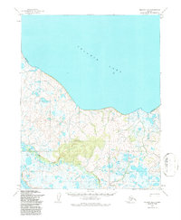
1955 Map of Selawik B-4
USGS Topo · Published 1968About this map
The vast expanse of Selawik Lake dominates the northern horizon of this mid-century survey, its southern shoreline marked by a complex network of wetlands and tundra. This remote Arctic landscape, as documented in 1955, shows a environment defined by seasonal movement and indigenous land use. A Winter Trail cuts across the southwestern terrain, reflecting the vital overland routes used when the ground is frozen. Near the banks of the Kauk River, the Reindeer Station stands as a significant cultural and economic landmark, tied to the history of herd management in the region. Prominent elevations such as Scholtz, South, Middle, and the rising ground of Selawik provide the few distinct topographical relief points in a territory otherwise shaped by meandering water and permafrost features.
Find a feature on this map
8 named features on this map. Tap any name to fly to it.
Don’t see what you’re looking for? This feature index may not catch every label — zoom into the map to look around manually.
Map Details
Editions of this 1955 Selawik B-4 Map
2 editions found
Other maps of this area

1951 · Selawik
USGS Topo · 1:250,000

1951 · Selawik A-5
USGS Topo · 1:63,360

1951 · Selawik B-5
USGS Topo · 1:63,360

1955 · Selawik A-4
USGS Topo · 1:63,360

1955 · Selawik B-3
USGS Topo · 1:63,360

1955 · Selawik C-3
USGS Topo · 1:63,360

1955 · Selawik A-3
USGS Topo · 1:63,360

1955 · Selawik C-5
USGS Topo · 1:63,360

1955 · Selawik C-4
USGS Topo · 1:63,360

1957 · Selawik
USGS Topo · 1:250,000