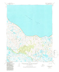
1955 Map of Selawik B-4
USGS Topo · Published 1987About this map
Selawik Lake dominates the northern half of this landscape, its expansive shoreline defining the transition into the wetlands and tundra of northwest Alaska. The interior terrain is characterized by a complex network of small lakes and seasonal ponds, particularly surrounding the Kauk River as it meanders through the low-lying coastal plain. Human activity is concentrated around Reindeer Station, a significant point of historical interest for those studying early twentieth-century herding practices and indigenous land use in the region. A Winter Trail provides a rare terrestrial route through this water-rich environment, cutting across the marshes toward the elevated prominence of Scholtz. Much of the territory is managed under the designation of Amnwr, reflecting the area's importance as a sanctuary for migratory birds and arctic wildlife during the mid-1950s.
Find a feature on this map
6 named features on this map. Tap any name to fly to it.
Don’t see what you’re looking for? This feature index may not catch every label — zoom into the map to look around manually.
Map Details
Editions of this 1955 Selawik B-4 Map
2 editions found
Other maps of this area

1951 · Selawik
USGS Topo · 1:250,000

1951 · Selawik A-5
USGS Topo · 1:63,360

1951 · Selawik B-5
USGS Topo · 1:63,360

1955 · Selawik A-4
USGS Topo · 1:63,360

1955 · Selawik B-3
USGS Topo · 1:63,360

1955 · Selawik C-3
USGS Topo · 1:63,360

1955 · Selawik A-3
USGS Topo · 1:63,360

1955 · Selawik B-4
USGS Topo · 1:63,360

1955 · Selawik C-5
USGS Topo · 1:63,360

1955 · Selawik C-4
USGS Topo · 1:63,360