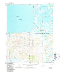
1955 Map of Selawik B-3
USGS Topo · Published 1987About this map
Selawik Lake dominates the northwestern portion of this mid-century topographic study, marking a landscape where water and wetlands define the geography. The area transition from the open expanse of the lake into a complex network of smaller water bodies and river systems, including Tuklomarak Lake and Inland Lake. The lower elevations are characterized by intricate hydrology, notably the winding courses of the Mangoak River and Fox River. Much of this territory is contained within the Selawik National Wildlife Refuge, reflecting the region's importance as a natural habitat. While the northern half is water-heavy, the southern terrain rises into significant topographical relief, shown through detailed contouring that illustrates the elevation changes south of the coastal wetlands. The map represents the region's state in the mid-1950s, prior to later administrative revisions.
Find a feature on this map
9 named features on this map. Tap any name to fly to it.
Don’t see what you’re looking for? This feature index may not catch every label — zoom into the map to look around manually.
Map Details
Editions of this 1955 Selawik B-3 Map
2 editions found
Other maps of this area

1951 · Selawik
USGS Topo · 1:250,000

1955 · Selawik A-4
USGS Topo · 1:63,360

1955 · Selawik B-3
USGS Topo · 1:63,360

1955 · Selawik C-3
USGS Topo · 1:63,360

1955 · Selawik A-3
USGS Topo · 1:63,360

1955 · Selawik B-4
USGS Topo · 1:63,360

1955 · Selawik C-4
USGS Topo · 1:63,360

1957 · Selawik
USGS Topo · 1:250,000
1985 · Selawik A-2
USGS Topo · 1:63,360
1985 · Selawik B-2
USGS Topo · 1:63,360