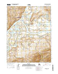
2015 Map of Selawik D-3 NW
USGS Topo · Published 2015About this map
Kiana sits at the confluence of the Squirrel River and the Kobuk River, serving as a vital hub in the Northwest Arctic Borough. This 2015 survey highlights the community's infrastructure, including the Bob Baker Memorial Airport and a small network of local thoroughfares such as Taylor Road and Beach Road. The geography is defined by the winding course of the Kobuk River as it traverses the Alaskan wilderness, joined by tributaries like Portage Cr and Unmanokak Cr. The layout of the town and its proximity to these major waterways illustrate the enduring importance of river systems for transportation and subsistence in this part of Alaska, even as modern aviation provides a secondary connection to the outside world via the memorial airport.
Find a feature on this map
15 named features on this map. Tap any name to fly to it.
Don’t see what you’re looking for? This feature index may not catch every label — zoom into the map to look around manually.
Map Details
Editions of this 2015 Selawik D-3 NW Map
This is the sole edition of this map. No revisions or reprints were ever made.
Other maps of this area

1951 · Baird Mountains
USGS Topo · 1:250,000

1951 · Selawik
USGS Topo · 1:250,000

1955 · Selawik D-4
USGS Topo · 1:63,360

1955 · Selawik D-3
USGS Topo · 1:63,360

1955 · Baird Mountains A-3
USGS Topo · 1:63,360

1955 · Baird Mountains A-4
USGS Topo · 1:63,360

1956 · Baird Mountains
USGS Topo · 1:250,000

1957 · Selawik
USGS Topo · 1:250,000

1965 · Baird Mountains
USGS Topo · 1:250,000
2015 · Selawik D-3 SE
USGS Topo · 1:25,000