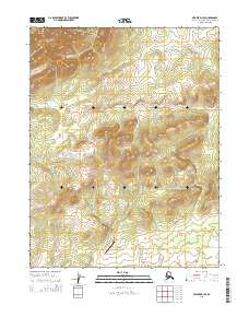
2015 Map of Selawik D-3 SE
USGS Topo · Published 2015About this map
Hockley Hills dominate the northern landscape of this interior Alaska quadrangle, situated in the Northwest Arctic region. The terrain is defined by a series of drainages, most notably Naluk Cr flowing through the northern slopes and the winding path of Oblaxon Cr further south. A significant human imprint on this remote area is the Roland Norton Memorial Airstrip, located in the southern portion of the sheet near the border of t16n r7w. The map provides a precise look at the township and range divisions, illustrating the systematic Public Land Survey System grid across these foothills. This 2015 survey is particularly valuable for documenting backcountry aviation infrastructure and small watercourses in a region where few permanent settlements are established.
Find a feature on this map
8 named features on this map. Tap any name to fly to it.
Don’t see what you’re looking for? This feature index may not catch every label — zoom into the map to look around manually.
Map Details
Editions of this 2015 Selawik D-3 SE Map
This is the sole edition of this map. No revisions or reprints were ever made.
Other maps of this area

1951 · Selawik
USGS Topo · 1:250,000

1955 · Selawik D-2
USGS Topo · 1:63,360

1955 · Selawik C-3
USGS Topo · 1:63,360

1955 · Selawik D-3
USGS Topo · 1:63,360

1957 · Selawik
USGS Topo · 1:250,000
1985 · Selawik C-2
USGS Topo · 1:63,360
2015 · Selawik D-3 NW
USGS Topo · 1:25,000
2015 · Selawik D-2 SW
USGS Topo · 1:25,000
2015 · Selawik C-2 NW
USGS Topo · 1:25,000
2015 · Selawik D-3 SW
USGS Topo · 1:25,000