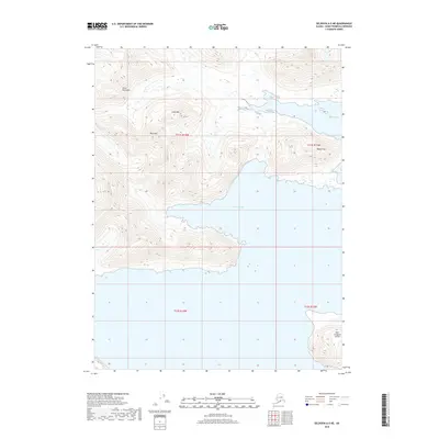
2018 Map of Seldovia A-5 NE
USGS Topo · Published 2018About this map
The Kenai Peninsula coastline dominates this 2018 survey, where steep terrain meets the waters of the Gulf of Alaska. The landscape is defined by significant elevations such as Cone Mtn and Rock Mtn, which rise sharply from the shoreline of Chugach Bay. This coastal environment is characterized by dramatic indentations and secluded inlets like Windy Bay to the northeast. Offshore, the prominent landmass of East Chugach Island stands separated from the mainland, highlighting the fractured geography of the region. To the east, Badger Hill provides another notable topographic marker in an area where the transition from sea level to mountain peaks is immediate and steep, reflecting the unpopulated and maritime-focused nature of this portion of the peninsula.
Find a feature on this map
11 named features on this map. Tap any name to fly to it.
Don’t see what you’re looking for? This feature index may not catch every label — zoom into the map to look around manually.
Map Details
Editions of this 2018 Seldovia A-5 NE Map
This is the sole edition of this map. No revisions or reprints were ever made.
Other maps of this area

1951 · Seldovia
USGS Topo · 1:250,000

1951 · Seldovia B-5
USGS Topo · 1:63,360

1951 · Seldovia B-4
USGS Topo · 1:63,360

1951 · Seldovia A-4
USGS Topo · 1:63,360

1953 · Seldovia B-4
USGS Topo · 1:63,360

1953 · Seldovia A-5
USGS Topo · 1:63,360

1953 · Seldovia B-5
USGS Topo · 1:63,360
1953 · Seldovia A-4
USGS Topo · 1:63,360

1963 · Seldovia
USGS Topo · 1:250,000
1981 · Seldovia B-4
USGS Topo · 1:63,360