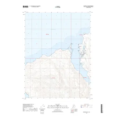
2018 Map of Seldovia B-5 NW
USGS Topo · Published 2018About this map
Seldovia sits at the northern edge of the Kenai Peninsula, where the waters of Seldovia Bay meet the Pacific Ocean. This coastal community is defined by its maritime geography, with the local street grid including Main Street and Shoreline Drive following the contours of the rugged coastline. Navigation and access are anchored by the Seldovia Airport and several prominent coastal landmarks such as Point Naskowhak and Seldovia Point. To the south, the terrain rises into steep elevations, drained by the tidal movements of Seldovia Slough and Johnson Slough. The presence of distinctive coastal features like Camel Rock, Red Bluff, and Powder Island highlights the geological character of the shoreline. The map also records the critical infrastructure connecting the community, including Jakalof Bay Road and Water Supply Road, which penetrate the interior landscape.
Find a feature on this map
26 named features on this map. Tap any name to fly to it.
Don’t see what you’re looking for? This feature index may not catch every label — zoom into the map to look around manually.
Map Details
Editions of this 2018 Seldovia B-5 NW Map
This is the sole edition of this map. No revisions or reprints were ever made.
Other maps of this area

1946 · Seldovia C-5
USGS Topo · 1:63,360

1951 · Seldovia C-5
USGS Topo · 1:63,360

1951 · Seldovia
USGS Topo · 1:250,000

1951 · Seldovia B-5
USGS Topo · 1:63,360

1951 · Seldovia B-6
USGS Topo · 1:63,360

1953 · Seldovia B-6
USGS Topo · 1:63,360

1953 · Seldovia B-5
USGS Topo · 1:63,360

1961 · Seldovia C-5
USGS Topo · 1:63,360

1963 · Seldovia
USGS Topo · 1:250,000
1987 · Seldovia B-6 NE
USGS Topo · 1:25,000