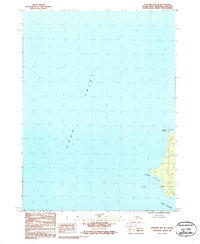
1987 Map of Seldovia B-6 NE
USGS Topo · Published 1987About this map
The coastal waters of Cook Inlet meet the rugged shoreline of the Kenai Peninsula in this late 1980s topographical survey. The map focuses on a treacherous stretch of maritime geography where the inlet narrows towards Port Graham. Navigation through these waters is marked by Dangerous Light, situated on a prominent landform known as Dangerous Cape. The eastern edge of the sheet reveals steep coastal elevations rising sharply from the sea, a characteristic feature of the Seldovia region. To the north, Point Pogibshi stands as a significant landmark for those tracing the historical shipping routes and maritime hazards of the southern peninsula. This provisional edition provides a detailed look at the interface between the sea and the uninhabited coastal peaks, including the triangulation station at Bird 2.
Find a feature on this map
6 named features on this map. Tap any name to fly to it.
Don’t see what you’re looking for? This feature index may not catch every label — zoom into the map to look around manually.
Map Details
Editions of this 1987 Seldovia B-6 NE Map
This is the sole edition of this map. No revisions or reprints were ever made.
Other maps of this area

1946 · Seldovia C-5
USGS Topo · 1:63,360

1951 · Seldovia C-5
USGS Topo · 1:63,360

1951 · Seldovia
USGS Topo · 1:250,000

1951 · Seldovia B-5
USGS Topo · 1:63,360

1951 · Seldovia B-6
USGS Topo · 1:63,360

1953 · Seldovia B-6
USGS Topo · 1:63,360

1953 · Seldovia B-5
USGS Topo · 1:63,360

1961 · Seldovia C-5
USGS Topo · 1:63,360

1963 · Seldovia
USGS Topo · 1:250,000
1987 · Seldovia B-5 NW
USGS Topo · 1:25,000