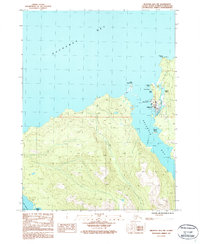
1987 Map of Seldovia B-5 NW
USGS Topo · Published 1987About this map
The coastal settlement of Seldovia serves as the primary focal point of this Kenai Peninsula study, situated at the entrance to Seldovia Bay. Compiled from 1980 aerial photography, the landscape is defined by its deep maritime connections, with navigation aids like the Light marking the approach to the docks and a local Landing Strip providing essential air access to this isolated shoreline. To the north, Kachemak Bay dominates the horizon, while the intricate coast is peppered with landmarks such as Camel Rock, Red Bluff, and Gray Cliff. The map provides a detailed view of the town's early infrastructure, including a local Cem and the protected waters of Seldovia Lagoon. Further south, the map traces the shoreline past Powder Island toward the waters of Port Graham, documenting the mix of steep coastal topography and tidal sloughs like Johnson Slough.
Find a feature on this map
23 named features on this map. Tap any name to fly to it.
Don’t see what you’re looking for? This feature index may not catch every label — zoom into the map to look around manually.
Map Details
Editions of this 1987 Seldovia B-5 NW Map
This is the sole edition of this map. No revisions or reprints were ever made.
Other maps of this area

1946 · Seldovia C-5
USGS Topo · 1:63,360

1951 · Seldovia C-5
USGS Topo · 1:63,360

1951 · Seldovia
USGS Topo · 1:250,000

1951 · Seldovia B-5
USGS Topo · 1:63,360

1951 · Seldovia B-6
USGS Topo · 1:63,360

1953 · Seldovia B-6
USGS Topo · 1:63,360

1953 · Seldovia B-5
USGS Topo · 1:63,360

1961 · Seldovia C-5
USGS Topo · 1:63,360

1963 · Seldovia
USGS Topo · 1:250,000
1987 · Seldovia B-6 NE
USGS Topo · 1:25,000