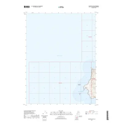
2018 Map of Seldovia B-6 NE
USGS Topo · Published 2018About this map
Pacific Ocean waters dominate this coastal survey of the western Kenai Peninsula, where the shoreline is defined by hazardous maritime features and deep inlets. Along the eastern edge, the land rises sharply at Point Pogibshi, extending southward toward the prominent Dangerous Cape. The name itself, along with the nearby Dangerous Cape Reef and Bird Reef, highlights the navigational perils of this stretch of the Alaskan coast. Tucked behind the protection of the cape, Coal Cove and the northern entrance to Port Graham offer the only significant indentation in an otherwise exposed coastline. This 2018 mapping project provides a clear record of the relationship between these remote landforms and the surrounding sea, showing the surveyed township boundaries of T8S R15W and T9S R15W as they intersect the rugged coastal topography.
Find a feature on this map
10 named features on this map. Tap any name to fly to it.
Don’t see what you’re looking for? This feature index may not catch every label — zoom into the map to look around manually.
Map Details
Editions of this 2018 Seldovia B-6 NE Map
This is the sole edition of this map. No revisions or reprints were ever made.
Other maps of this area

1946 · Seldovia C-5
USGS Topo · 1:63,360

1951 · Seldovia C-5
USGS Topo · 1:63,360

1951 · Seldovia
USGS Topo · 1:250,000

1951 · Seldovia B-5
USGS Topo · 1:63,360

1951 · Seldovia B-6
USGS Topo · 1:63,360

1953 · Seldovia B-6
USGS Topo · 1:63,360

1953 · Seldovia B-5
USGS Topo · 1:63,360

1961 · Seldovia C-5
USGS Topo · 1:63,360

1963 · Seldovia
USGS Topo · 1:250,000
1987 · Seldovia B-6 NE
USGS Topo · 1:25,000