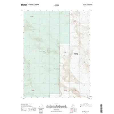
2017 Map of Seldovia C-3 SE
USGS Topo · Published 2017About this map
Grewingk Glacier and Petrof Glacier define this glacial landscape in the southern Kenai Mountains, where ice and rock dominate the topography. This 2017 survey documents a high-altitude wilderness divided between two major federal conservation areas: Kenai National Wildlife Refuge to the west and Kenai Fjords National Park to the east. The terrain is marked by sharp elevation changes, with prominent summits like Iceworm Peak and Needle Peak rising above the ice fields. This map serves as a detailed record of contemporary glacial extent, showing the massive flows of Dixon Glacier, Portlock Glacier, and Wosnesenski Glacier before they descend into lower valleys. The lack of roads or settlements emphasizes the remote nature of this part of the Kenai Peninsula, where natural boundaries like Township 7 South and Range 10 West organize the vast, unpopulated terrain.
Find a feature on this map
17 named features on this map. Tap any name to fly to it.
Don’t see what you’re looking for? This feature index may not catch every label — zoom into the map to look around manually.
Map Details
Editions of this 2017 Seldovia C-3 SE Map
This is the sole edition of this map. No revisions or reprints were ever made.
Other maps of this area

1951 · Seldovia
USGS Topo · 1:250,000

1951 · Seldovia B-2
USGS Topo · 1:63,360

1951 · Seldovia B-3
USGS Topo · 1:63,360

1951 · Seldovia C-3
USGS Topo · 1:63,360

1952 · Seldovia B-3
USGS Topo · 1:63,360

1953 · Seldovia C-3
USGS Topo · 1:63,360

1953 · Seldovia B-2
USGS Topo · 1:63,360

1953 · Seldovia C-2
USGS Topo · 1:63,360

1963 · Seldovia
USGS Topo · 1:250,000
1987 · Seldovia C-3 NW
USGS Topo · 1:25,000