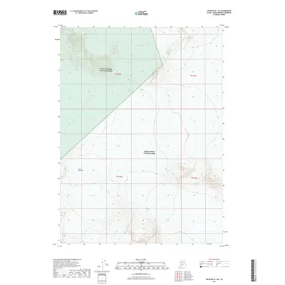
2017 Map of Seldovia D-1 NE
USGS Topo · Published 2017About this map
Glacial movement and conservation boundaries define this high-altitude section of the southern Kenai Peninsula. The landscape is almost entirely divided between two major federal designations: the Kenai National Wildlife Refuge to the northwest and Kenai Fjords National Park across the central and southern portions of the sheet. This 2017 survey documents the massive ice fields and active glaciers that dominate the terrain, including Aialik Glacier in the northeast and Tustumena Glacier near the wildlife refuge boundary. Further south, the presence of Northwestern Glacier and Holgate Glacier indicates the complex glacial system feeding into the fjords. The map provides a precise record of these ice margins at a specific moment in the early 21st century, offering a baseline for studying environmental change and the topographic character of this roadless wilderness.
Find a feature on this map
11 named features on this map. Tap any name to fly to it.
Don’t see what you’re looking for? This feature index may not catch every label — zoom into the map to look around manually.
Map Details
Editions of this 2017 Seldovia D-1 NE Map
This is the sole edition of this map. No revisions or reprints were ever made.
Other maps of this area

1944 · Kenai
USGS Topo · 1:250,000

1946 · Blying Sound
USGS Topo · 1:250,000

1950 · Kenai
USGS Topo · 1:250,000

1950 · Seward A-8
USGS Topo · 1:63,360

1951 · Blying Sound
USGS Topo · 1:250,000

1951 · Seward
USGS Topo · 1:250,000

1951 · Seldovia
USGS Topo · 1:250,000

1951 · Kenai A-1
USGS Topo · 1:63,360
1951 · Blying Sound D-8
USGS Topo · 1:63,360

1951 · Seward A-8
USGS Topo · 1:63,360