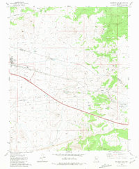
1981 Map of Seligman East
USGS Topo · Published 1981About this map
Seligman serves as the focal point for this high-desert plateau survey, where the convergence of historic transportation routes and livestock infrastructure defines the local economy. The massive corridor of the Atchison Topeka and Santa Fe Railroad cuts across the landscape, paralleled by the iconic Route 66 and Interstate 40. Within the town, community life is anchored by the High Sch and an adjacent Athletic Field, while the surrounding arid terrain is dotted with critical water management features like Padre Reservoir, Wagner Tank, and Sinkhole Tank. The map also reveals the area's industrial activity through several Cinder Pits and a Gravel Pit, supporting road and rail maintenance. Resource management for ranching is evident in the numerous Corrals and a Pumping Station near the Cedar Berry Tank at the edge of the Coconino and Yavapai county line.
Find a feature on this map
29 named features on this map. Tap any name to fly to it.
Don’t see what you’re looking for? This feature index may not catch every label — zoom into the map to look around manually.
Map Details
Editions of this 1981 Seligman East Map
2 editions found
Other maps of this area

1886 · Chino
USGS Topo · 1:250,000

1891 · Chino
USGS Topo · 1:250,000

1947 · Picacho Butte
USGS Topo · 1:62,500

1947 · Turkey Canyon
USGS Topo · 1:62,500

1948 · Williams
USGS Topo · 1:250,000

1948 · Picacho Butte
USGS Topo · 1:63,360

1950 · Turkey Canyon
USGS Topo · 1:62,500

1950 · Picacho Butte
USGS Topo · 1:62,500

1954 · Williams
USGS Topo · 1:250,000

1956 · Williams
USGS Topo · 1:250,000