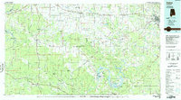
1986 Map of Selma
USGS Topo · Published 1986About this map
The Tombigbee River and Alabama River systems define this mid-1980s landscape, serving as the backdrop for a region defined by its rail hubs and river infrastructure. The city of Selma and neighboring West Selma stand as the primary population centers, while the historic site of Cahaba sits at the confluence of the Cahaba and Alabama Rivers. The infrastructure of the era is evident at the Millers Ferry Lock and Dam, which regulates the waters of Claiborne Lake.
Find a feature on this map
179 named features on this map. Tap any name to fly to it.
Don’t see what you’re looking for? This feature index may not catch every label — zoom into the map to look around manually.
Map Details
Editions of this 1986 Selma Map
2 editions found
Other maps of this area

1891 · Clanton
USGS Topo · 1:125,000

1929 · Epes
USGS Topo · 1:48,000

1932 · Epes
USGS Topo · 1:62,500

1946 · Demopolis
USGS Topo · 1:24,000

1947 · Demopolis
USGS Topo · 1:24,000

1948 · Mc Dowell
USGS Topo · 1:24,000

1949 · Mc Dowell
USGS Topo · 1:24,000

1953 · Montgomery
USGS Topo · 1:250,000

1953 · Andalusia
USGS Topo · 1:250,000

1953 · Hattiesburg
USGS Topo · 1:250,000