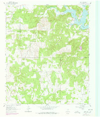
1961 Map of Selma
USGS Topo · Published 1978About this map
Lake Amon G. Carter dominates the northeastern corner of this landscape, its fingers reaching into the surrounding terrain near the settlement of Selma. The map documents a period of significant petroleum development, particularly within the Bowie SW Oil Field, where numerous oil wells are scattered across the drainage basins of Big Sandy Creek and Cottonwood Creek. This energy production exists alongside older rural foundations, marked by the presence of Selma Cem and Crafton Cem. The topography is defined by a dense network of waterways including Cowsert Creek, Venchoner Creek, and Herring Branch, which carved the complex ridgelines and valleys before the land reaches the community of Kiel. The survey also delineates the convergence of four county lines—Montague, Clay, Jack, and Wise—illustrating the jurisdictional complexity of this North Texas region.
Find a feature on this map
23 named features on this map. Tap any name to fly to it.
Don’t see what you’re looking for? This feature index may not catch every label — zoom into the map to look around manually.
Map Details
Editions of this 1961 Selma Map
2 editions found
Other maps of this area

1905 · Montague
USGS Topo · 1:125,000

1954 · Sherman
USGS Topo · 1:250,000

1954 · Wichita Falls
USGS Topo · 1:250,000

1958 · Wichita Falls
USGS Topo · 1:250,000

1958 · Sherman
USGS Topo · 1:250,000

1961 · Brushy Mound
USGS Topo · 1:24,000

1961 · Selma
USGS Topo · 1:24,000

1961 · Sunset
USGS Topo · 1:24,000

1961 · Bowie
USGS Topo · 1:24,000

1961 · Crafton
USGS Topo · 1:24,000