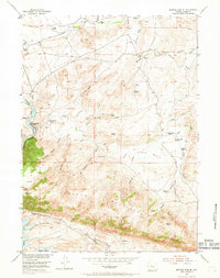
1953 Map of Seminoe Dam NE
USGS Topo · Published 1969About this map
The Seminoe Mountains dominate this 1953 landscape, where the North Platte River carves through deep canyons and feeds the Seminoe Reservoir. This high-desert region of Carbon County reveals a network of mid-century cattle operations, including the Vivian Ranch, Hamilton Ranch, and Nine Bar W Ranch. The geography is defined by complex drainage systems like Number One, Number Two, and Number Three Gulch, which cut toward the river valley. Sparse but vital infrastructure for local families is evident at Threemile School and Lost Creek School, alongside recreational and social hubs like the Sage Creek Clubhouse. The presence of Kortes Dam Camp near Seminoe Canyon reflects the era's focus on water management and energy development in the Missouri River Basin. To the northeast, the Shirley Basin Road provides a corridor through the Shirley Basin, connecting these remote ranching outposts to the wider region.
Find a feature on this map
49 named features on this map. Tap any name to fly to it.
Don’t see what you’re looking for? This feature index may not catch every label — zoom into the map to look around manually.
Map Details
Editions of this 1953 Seminoe Dam NE Map
3 editions found
Other maps of this area

1953 · Leo
USGS Topo · 1:24,000

1953 · Seminoe Dam NE
USGS Topo · 1:24,000

1953 · Seminoe Dam
USGS Topo · 1:24,000

1953 · Seminoe Dam SW
USGS Topo · 1:24,000

1953 · Pathfinder Reservoir SW
USGS Topo · 1:24,000

1953 · Seminoe Dam SE
USGS Topo · 1:24,000

1953 · Fourmile Ridge
USGS Topo · 1:24,000

1953 · Schneider Ridge
USGS Topo · 1:24,000

1953 · Beaver Creek
USGS Topo · 1:24,000

1955 · Casper
USGS Topo · 1:250,000