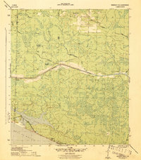
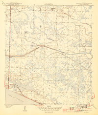
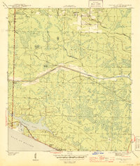
1944 Map of Seminole Hills
USGS Topo · Published 1944This historical map portrays the area of Seminole Hills in 1944, primarily covering Bay County as well as portions of Walton County. Featuring a scale of 1:31680, this map provides a highly detailed snapshot of the terrain, roads, buildings, counties, and historical landmarks in the Seminole Hills region at the time. Published in 1944, it is one of 4 known editions of this map due to revisions or reprints.
Find a feature on this map
22 named features on this map. Tap any name to fly to it.
Don’t see what you’re looking for? This feature index may not catch every label — zoom into the map to look around manually.
Map Details
Editions of this 1944 Seminole Hills Map
4 editions found
Historical Maps of Seminole Hills Through Time
50 maps found

1943 Beacon Beach
Bay County, FL

1943 Crooked Island
Bay County, FL

1943 Seminole Hills
Bay County, FL

1943 Southport
Bay County, FL

1943 West Bay
Bay County, FL

1944 Bayhead
Bay County, FL

1944 Beacon Hill
Bay County, FL

1944 Bennett
Bay County, FL

1944 Crystal Lake
Bay County, FL

1944 Long Point
Bay County, FL

1944 Seminole Hills
Bay County, FL

1944 Southport
Bay County, FL

1944 West Bay
Bay County, FL

1945 Allanton
Bay County, FL

1945 Bayhead
Bay County, FL

1945 Bennett
Bay County, FL

1945 Crystal Lake
Bay County, FL

1945 Fountain
Bay County, FL

1945 North Of Allanton
Bay County, FL

1945 Red Head
Bay County, FL

1945 Youngstown
Bay County, FL

1947 Allanton
Bay County, FL

1952 Compass Lake
Bay County, FL

1956 Allanton
Bay County, FL

1956 Beacon Beach
Bay County, FL

1956 Beacon Hill
Bay County, FL

1956 Crooked Island
Bay County, FL

1956 Long Point
Bay County, FL

1956 North Of Allanton
Bay County, FL

1982 Allanton
Bay County, FL

1982 Bayhead
Bay County, FL

1982 Beacon Beach
Bay County, FL

1982 Beacon Hill
Bay County, FL

1982 Bennett
Bay County, FL

1982 Compass Lake
Bay County, FL

1982 Crooked Island
Bay County, FL

1982 Crystal Lake
Bay County, FL

1982 Fountain
Bay County, FL

1982 Long Point
Bay County, FL

1982 North Of Allanton
Bay County, FL

1982 Red Head
Bay County, FL

1982 Seminole Hills
Bay County, FL

1982 Southport
Bay County, FL

1982 West Bay
Bay County, FL

1982 Youngstown
Bay County, FL

1994 Beacon Beach
Bay County, FL

1994 Compass Lake
Bay County, FL

1994 Crooked Island
Bay County, FL

1994 Red Head
Bay County, FL

1994 West Bay
Bay County, FL