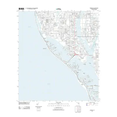
2012 Map of Seminole
USGS Topo · Published 2012About this map
Boca Ciega Bay and the complex barrier islands of Florida's Gulf coast define this 2012 survey. The landscape is characterized by a dense network of residential finger canals and bridges, connecting mainland areas like The Garden Sanctuary to the shore. A significant landmark on the eastern shore of Long Bayou is the Bay Pines National Cem, situated near the crossing of Bay Pines Blvd.
Find a feature on this map
40 named features on this map. Tap any name to fly to it.
Don’t see what you’re looking for? This feature index may not catch every label — zoom into the map to look around manually.
Map Details
Editions of this 2012 Seminole Map
This is the sole edition of this map. No revisions or reprints were ever made.
Other maps of this area

1921 · Sand Key
USGS Topo · 1:62,500

1921 · Fort De Soto
USGS Topo · 1:62,500

1921 · St Petersburg
USGS Topo · 1:62,500

1943 · St Petersburg
USGS Topo · 1:31,680

1943 · Pass-A-Grille
USGS Topo · 1:31,680

1943 · Bay Pines
USGS Topo · 1:31,680

1943 · Safety Harbor
USGS Topo · 1:31,680

1943 · Clearwater
USGS Topo · 1:24,000

1947 · St Petersburg
USGS Topo · 1:25,000
1947 · Safety Harbor
USGS Topo · 1:24,000