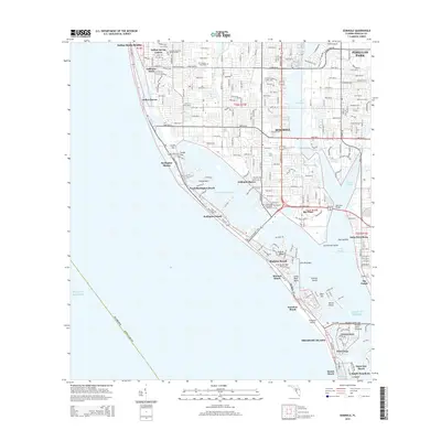
2015 Map of Seminole
USGS Topo · Published 2015About this map
Seminole and the surrounding coastal communities of Pinellas County are presented here in a complex network of barrier islands and intracoastal waterways. This modern survey illustrates the dense residential development that has come to define the region, from Indian Rocks Beach down to Treasure Island. Notable institutions like the St. Petersburg Theological Seminary and local landmarks such as The Garden Sanctuary are situated among a landscape of suburban streets and man-made inlets. The geography of the Gulf coast is prominent, featuring the Intracoastal Waterway and various keys such as Conch Key and Tripod Key. Inland, the map details significant water bodies like Lake Seminole and the residential enclaves of Indian Spring Estates and Oakhurst Acres, providing a clear picture of the mid-2010s land use and infrastructure across this Florida peninsula.
Find a feature on this map
197 named features on this map. Tap any name to fly to it.
Don’t see what you’re looking for? This feature index may not catch every label — zoom into the map to look around manually.
Map Details
Editions of this 2015 Seminole Map
This is the sole edition of this map. No revisions or reprints were ever made.
Other maps of this area

1921 · Sand Key
USGS Topo · 1:62,500

1921 · Fort De Soto
USGS Topo · 1:62,500

1921 · St Petersburg
USGS Topo · 1:62,500

1943 · St Petersburg
USGS Topo · 1:31,680

1943 · Pass-A-Grille
USGS Topo · 1:31,680

1943 · Bay Pines
USGS Topo · 1:31,680

1943 · Safety Harbor
USGS Topo · 1:31,680

1943 · Clearwater
USGS Topo · 1:24,000

1947 · St Petersburg
USGS Topo · 1:25,000
1947 · Safety Harbor
USGS Topo · 1:24,000