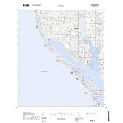
2024 Map of Seminole
USGS Topo · Published 2024About this map
Seminole and the surrounding barrier islands are defined by an intricate network of waterways where the Intracoastal Waterway threads between the mainland and the Gulf of Mexico. This modern survey illustrates the dense residential development from Indian Shores down to Treasure Island, showing how the land has been reshaped into finger islands like Isle of Palms and Capri Isle. A prominent landmark on the mainland is the Bay Pines National Cemetery, situated near the head of Long Bayou. Further inland, the landscape features large bodies of water such as Lake Seminole and Blossom Lake, which contrast with the coastal environment of Johns Pass and Boca Ciega Bay. The map provides a contemporary view of the region's complex infrastructure, including Saint Petersburg College and major thoroughfares like Gulf Blvd and Bay Pines Blvd N.
Find a feature on this map
54 named features on this map. Tap any name to fly to it.
Don’t see what you’re looking for? This feature index may not catch every label — zoom into the map to look around manually.
Map Details
Editions of this 2024 Seminole Map
This is the sole edition of this map. No revisions or reprints were ever made.
Other maps of this area

1921 · Sand Key
USGS Topo · 1:62,500

1921 · Fort De Soto
USGS Topo · 1:62,500

1921 · St Petersburg
USGS Topo · 1:62,500

1943 · St Petersburg
USGS Topo · 1:31,680

1943 · Pass-A-Grille
USGS Topo · 1:31,680

1943 · Bay Pines
USGS Topo · 1:31,680

1943 · Safety Harbor
USGS Topo · 1:31,680

1943 · Clearwater
USGS Topo · 1:24,000

1947 · St Petersburg
USGS Topo · 1:25,000
1947 · Safety Harbor
USGS Topo · 1:24,000