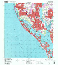
1995 Map of Seminole
USGS Topo · Published 1999About this map
Boca Ciega Bay and the barrier island chain define this coastal landscape, showing the dense residential finger-canals and developed waterfronts of the mid-1990s. The map illustrates a heavily suburbanized Pinellas County, where traditional landmarks like Chapel-on-the-Hill and the V A Hospital at Bay Pines sit amid a grid of retirement communities and modern infrastructure. To the north, the presence of the U S Reservation Pinellas Plant (AEC) points to the region's mid-century industrial role in national defense.
Find a feature on this map
75 named features on this map. Tap any name to fly to it.
Don’t see what you’re looking for? This feature index may not catch every label — zoom into the map to look around manually.
Map Details
Editions of this 1995 Seminole Map
This is the sole edition of this map. No revisions or reprints were ever made.
Other maps of this area

1921 · Sand Key
USGS Topo · 1:62,500

1921 · Fort De Soto
USGS Topo · 1:62,500

1921 · St Petersburg
USGS Topo · 1:62,500

1943 · St Petersburg
USGS Topo · 1:31,680

1943 · Pass-A-Grille
USGS Topo · 1:31,680

1943 · Bay Pines
USGS Topo · 1:31,680

1943 · Safety Harbor
USGS Topo · 1:31,680

1943 · Clearwater
USGS Topo · 1:24,000

1947 · St Petersburg
USGS Topo · 1:25,000
1947 · Safety Harbor
USGS Topo · 1:24,000