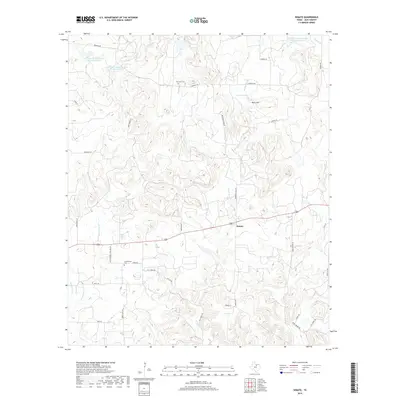
2019 Map of Senate
USGS Topo · Published 2019About this map
The small community of Senate sits along the southern edge of this landscape, serving as a focal point for the surrounding rural Jack County countryside. The terrain is defined by a series of distinct watercourses including Board Tree Cr and W Salt Cr, which carve through the elevations toward larger reservoirs. Agricultural history is evident in the network of county roads named for local families and landmarks, such as Berry Dairy Rd and Cottonwood Cemetery Rd. Genealogists will find interest in the well-marked Cottonwood Cem and Winn Hill Cem, while topographic landmarks like Tater Hill and the waters of Dearing Lake provide clear spatial orientation. The map also documents modern conservation efforts with several Soil Conservation Service reservoirs, illustrating the long-term management of this ranching and farming region.
Find a feature on this map
37 named features on this map. Tap any name to fly to it.
Don’t see what you’re looking for? This feature index may not catch every label — zoom into the map to look around manually.
Map Details
Editions of this 2019 Senate Map
This is the sole edition of this map. No revisions or reprints were ever made.
Other maps of this area

1954 · Wichita Falls
USGS Topo · 1:250,000

1958 · Wichita Falls
USGS Topo · 1:250,000

1960 · Jacksboro
USGS Topo · 1:24,000
1961 · Bartons Chapel
USGS Topo · 1:24,000

1964 · Senate
USGS Topo · 1:24,000

1964 · Johnson Lake
USGS Topo · 1:24,000

1964 · Bryson
USGS Topo · 1:24,000

1964 · Lynn Creek
USGS Topo · 1:24,000
1964 · Markley
USGS Topo · 1:24,000
1967 · Long Hollow
USGS Topo · 1:24,000