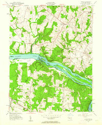
1952 Map of Seneca
USGS Topo · Published 1963About this map
The Potomac River corridor serves as the central artery for this mid-century landscape, where the Chesapeake and Ohio Canal parallels the river's Maryland shore near Seneca. The mapping reflects a transition between the established river-focused settlements of Montgomery County and the agricultural tracts of Loudoun and Fairfax Counties in Virginia. Notable landmarks like Blockhouse Point and a series of large river islands, including Watkins Island and Clagett Island, define the waterway's character before it reaches Great Falls. Inland, a network of historic roads such as River Road and the Leesburg Turnpike connect small communities and school sites like Forestville Sch. This survey, based on 1943 topography with 1952 cultural revisions, documents the region's rural structure before the rapid suburban expansion of the later 20th century, preserving the locations of numerous unnamed cemeteries and the early alignment of the Pipe Line.
Find a feature on this map
46 named features on this map. Tap any name to fly to it.
Don’t see what you’re looking for? This feature index may not catch every label — zoom into the map to look around manually.
Map Details
Editions of this 1952 Seneca Map
4 editions found
Other maps of this area

1890 · Mt. Vernon
USGS Topo · 1:125,000

1891 · Mt. Vernon
USGS Topo · 1:125,000

1893 · Frederick
USGS Topo · 1:125,000

1894 · Frederick
USGS Topo · 1:125,000

1894 · Mt. Vernon
USGS Topo · 1:125,000

1897 · Mt. Vernon
USGS Topo · 1:125,000

1900 · Washington
USGS Topo · 1:62,500

1908 · Rockville
USGS Topo · 1:62,500

1908 · Seneca
USGS Topo · 1:62,500

1915 · Fairfax
USGS Topo · 1:62,500