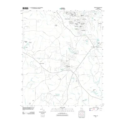
2011 Map of Senoia
USGS Topo · Published 2011About this map
Senoia serves as the focal point of this region, showing a transition from its established town center toward the expanding residential developments to the north. The area around Starrs Mill and the Starrs Mill Bridge along Whitewater Creek provides a clear look at how historical water-powered sites integrated into the modern landscape. The northern portion of the map is dense with planned communities like The Colonnade, Waterford Green, and Morallion Hills, reflecting the suburban growth surrounding Peachtree City-Falcon Field. Genealogists will find a high concentration of burial grounds throughout the countryside, including Senoia City Cemetery, Hartford Cemetery, and the more secluded Nixon Cemetery. The terrain is defined by a network of waterways such as Line Creek, Keg Creek, and Dead Oak Creek, which feed numerous small reservoirs like McKnight Lake and Hutchins Lake, illustrating the local reliance on dammed water for both recreation and land management.
Find a feature on this map
116 named features on this map. Tap any name to fly to it.
Don’t see what you’re looking for? This feature index may not catch every label — zoom into the map to look around manually.
Map Details
Editions of this 2011 Senoia Map
This is the sole edition of this map. No revisions or reprints were ever made.
Other maps of this area

1953 · Atlanta
USGS Topo · 1:250,000

1957 · Atlanta
USGS Topo · 1:250,000

1958 · Atlanta
USGS Topo · 1:250,000

1965 · Tyrone
USGS Topo · 1:24,000

1965 · Fayetteville
USGS Topo · 1:24,000

1965 · Madras
USGS Topo · 1:24,000

1965 · Senoia
USGS Topo · 1:24,000

1965 · Brooks
USGS Topo · 1:24,000

1965 · Sharpsburg
USGS Topo · 1:24,000
1971 · Luthersville
USGS Topo · 1:24,000