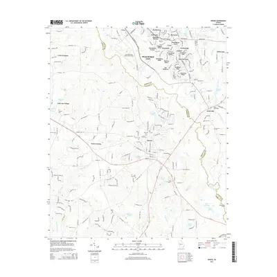
2014 Map of Senoia
USGS Topo · Published 2014About this map
Senoia serves as a central hub in this Coweta and Fayette County landscape, where the transition from historical rural industry to suburban residential development is clearly visible. The area around Starrs Mill and the Starrs Millpond highlights the importance of waterpower along Whitewater Creek, while the numerous cemeteries like Bethel Cem, Neriah Cem, and Oak Grove Cem provide essential anchor points for genealogists. To the north, the rapid growth of Peachtree City is evidenced by a dense network of residential developments such as Tamerlane and Waterford Green surrounding the Atlanta Regional Airport-Falcon Field. This documentation of the land preserves the names of smaller locales like Peeks Crossing and Clover, set against a backdrop of creeks including Line Creek and Keg Creek that historically defined property and county lines.
Find a feature on this map
70 named features on this map. Tap any name to fly to it.
Don’t see what you’re looking for? This feature index may not catch every label — zoom into the map to look around manually.
Map Details
Editions of this 2014 Senoia Map
This is the sole edition of this map. No revisions or reprints were ever made.
Other maps of this area

1953 · Atlanta
USGS Topo · 1:250,000

1957 · Atlanta
USGS Topo · 1:250,000

1958 · Atlanta
USGS Topo · 1:250,000

1965 · Tyrone
USGS Topo · 1:24,000

1965 · Fayetteville
USGS Topo · 1:24,000

1965 · Madras
USGS Topo · 1:24,000

1965 · Senoia
USGS Topo · 1:24,000

1965 · Brooks
USGS Topo · 1:24,000

1965 · Sharpsburg
USGS Topo · 1:24,000
1971 · Luthersville
USGS Topo · 1:24,000