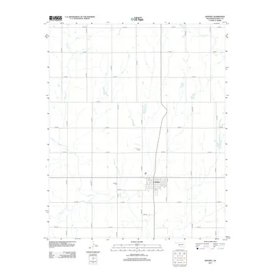
2012 Map of Sentinel
USGS Topo · Published 2012About this map
Sentinel serves as the central hub of this agricultural landscape in Washita County, Oklahoma. The town's grid is clearly defined by streets such as Pine St and 11th St, surrounded by a vast section-line road network including N2140 Rd and E 1285 Rd. The terrain is shaped by the drainage patterns of Spring Cr and Elk Cr, which meander through the prairie toward the southern and western reaches of the quadrangle. Local history and genealogy are anchored by the presence of Sentinel Cem and Huckleby Cem, while the Ridling Reservoir and Little Elk Cr provide critical water points in this rural environment. This survey captures the enduring layout of an Oklahoma farming community at the start of the 2010s, showing the intersection of natural waterways and modern infrastructure.
Find a feature on this map
29 named features on this map. Tap any name to fly to it.
Don’t see what you’re looking for? This feature index may not catch every label — zoom into the map to look around manually.
Map Details
Editions of this 2012 Sentinel Map
This is the sole edition of this map. No revisions or reprints were ever made.
Other maps of this area

1955 · Clinton
USGS Topo · 1:250,000

1957 · Clinton
USGS Topo · 1:250,000

1957 · Dill City
USGS Topo · 1:62,500

1961 · Hobart
USGS Topo · 1:62,500

1961 · Retrop
USGS Topo · 1:62,500

1961 · Elk City
USGS Topo · 1:62,500

1976 · Dill City SE
USGS Topo · 1:24,000

1983 · Dill City
USGS Topo · 1:24,000
1983 · Dill City SE
USGS Topo · 1:24,000

1984 · Sentinel
USGS Topo · 1:24,000