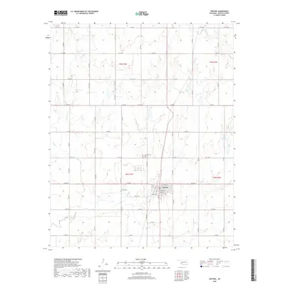
2018 Map of Sentinel
USGS Topo · Published 2018About this map
Sentinel serves as the primary hub of this Washita County landscape, where the town’s grid is anchored by a local Post Office and central streets like Washington and Lincoln. The surrounding terrain is defined by a dendritic network of seasonal waterways, including Spring Creek and Trail Creek, which feed into the larger Elk Creek drainage system. These creeks create a rolling topography that breaks the geometric regularity of the section lines and rural road network.
Find a feature on this map
53 named features on this map. Tap any name to fly to it.
Don’t see what you’re looking for? This feature index may not catch every label — zoom into the map to look around manually.
Map Details
Editions of this 2018 Sentinel Map
This is the sole edition of this map. No revisions or reprints were ever made.
Other maps of this area

1955 · Clinton
USGS Topo · 1:250,000

1957 · Clinton
USGS Topo · 1:250,000

1957 · Dill City
USGS Topo · 1:62,500

1961 · Hobart
USGS Topo · 1:62,500

1961 · Retrop
USGS Topo · 1:62,500

1961 · Elk City
USGS Topo · 1:62,500

1976 · Dill City SE
USGS Topo · 1:24,000

1983 · Dill City
USGS Topo · 1:24,000
1983 · Dill City SE
USGS Topo · 1:24,000

1984 · Sentinel
USGS Topo · 1:24,000